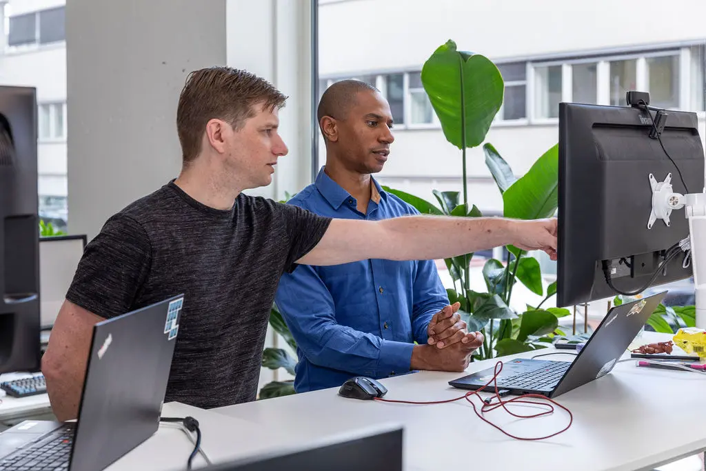
Harry van den Bergh (30) has been working at Sweco – a large engineering and consultancy firm with around 1600 employees in the Netherlands – since April 2020. Harry works as a soil consultant for the Environmental Consultancy department in Eindhoven. He lives in Utrecht and can therefore regularly be found at Sweco in De Bilt, a nearby town. As a soil consultant, he works daily with the TerraIndex soil survey software.
‘TerraIndex helps us generate and process field data quickly, which is essential for our work process and quality of the research.’
Sweco has several departments: our field of work is very broad
Since April 2020, I have been working at Sweco Nederland. Sweco is Europe’s largest engineering and consultancy firm, with more than 17,000 employees in total. Sweco’s field of work is very broad. There are three divisions in the Netherlands, under which a variety of departments fall. From managing landfills, excavating unexploded remains of war, hydraulic engineering, landscape architecture to climate and sustainability. I myself work for the Environmental Consultancy department, as a soil consultant.
TerraIndex is used in many crucial steps of our research
As a soil consultant, I’m usually involved in the execution of the soil survey – from the desk study to the advisory report. TerraIndex is used in many crucial steps of the investigation. I start by consulting the known sources and examine the area where the client wants to dig. This way, I determine what suspicious substances we might find there. I define a survey strategy and make a drilling plan so that the fieldworker can take the necessary samples. The samples are sent to the lab, after which I analyse the results and assemble an advisory report. I then discuss the advice with the client. ‘
As a consultant, you can quickly switch between the field worker, the data and the lab
I already knew the TerraIndex software kende ik al, aangezien mijn vorige werkgever – waar ik dezelfde functie had – hier ook mee werkte. Ik verwacht dat de meeste onderzoeksbureaus met TerraIndex werken, net als de grote laboratoria.
Het grote voordeel van TerraIndex is dat gegevens in het veld direct digitaal ingevoerd kunnen worden op een tablet of ander device. Labopdrachten kunnen daarmee snel aangemaakt worden en hoeven vervolgens alleen bevestigd te worden bij het lab. Je kunt als adviseur snel schakelen tussen veldwerker, de gegevens en het laboratorium. TerraIndex helpt ons snel veldgegevens te genereren en te verwerken, wat essentieel is voor ons werkproces en de kwaliteit van het onderzoek.’
The software makes performing my tasks more efficient
TerraIndex not only improves the cooperation between the different parties, but the software also makes the performance of my tasks more efficient. For example, it is compulsory to include the data collected in the field from all the boreholes – sometimes hundreds – in the survey report. Typing out all these borings, including XY coordinates and the name of the fieldworker, takes a lot of time. With TerraIndex, borehole profiles can be easily printed out, with the correct layout and including the legend. Other important data, such as sensory characteristics or the analyses carried out, can be tabulated and included in your report.
De gewenste gegevens, profielen en tabellen kunnen met een paar klikken in het adviesrapport geplakt worden. Doordat je uit verschillende templates kunt kiezen, is het opmaken van een adviesrapport zo gedaan.
Een andere handige – nog vrij nieuwe – functionaliteit is de lijst met labopdrachten, inclusief een voortgangsindicatie. Vinkjes geven aan of de labopdracht verzonden, ontvangen of afgerond is. Mocht er iets mis zijn gegaan met het verzenden, dan kun je snel ingrijpen. Je ziet in één oogopslag wanneer de resultaten binnen zijn, zodat je gelijk aan de slag kunt met het adviesrapport.’
If you run into problems, you can always call them
In the time that I have been working with TerraIndex, new functionalities have been added regularly. Often, this is already announced in our department. I myself receive an email from TerraIndex, in which the functionality is explained step by step. Often with screenshots or sometimes with an explanation video. Webinars are also organised regularly. If you run into problems, you can always call them, and they will help you quickly.
The user interface of TerraIndex is simple. This makes using TerraIndex very easy and intuitive. Personally, I would like to see a few more buttons. I can see opportunities to visualise more things, especially for the fieldworker. For example, a real-time display of a borehole profile with monitoring well, so that the fieldworker can immediately see whether the borehole profile and the depth of the monitoring well have been entered correctly. I myself would like to be able to display drilling profiles in a cross-section. Fortunately, work is already being done on the latter.
As far as I know TerraIndex, I expect that when more customers need a certain functionality, it will come in the future.